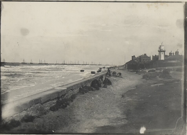
Here’s an old photo from a batch sent in sometime ago by Ian Davies. This one is the view from Kings Gap looking towards Meols and was titled Marine Parade – Before The Promenade. The sea wall was constructed between 1897-1898, there’s a commemorative plaque in the wall that you can see if you walk along the beach. So if the wall in the photo above is the one that’s there today, the North Parade pavement and road must have been constructed after 1898?
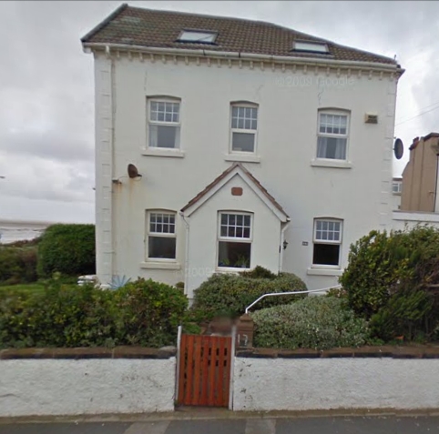
Look at how many boats are anchored off the shoreline. You can see the old lower lighthouse at the lifeboat station and I reckon that the house behind that with the angled roof is this one in Government Road:

Fantastic and fascinating historical photo (thank goodness for the amateur photographers of yesteryear) – the blocks in the wall certainly look very similar to the existing wall of the promenade, but I would imagine that in order to support the pressure of the back – fill and road traffic along the present day roadway, the rear side of the existing wall would need to be far more robust than this one appears? I wonder if this is indeed the same wall, or the existing one used some of the blocks from its predecessor? It’s also very interesting to see the lay of the land behind the wall – it suggests a gentle slope towards the beach which also indicates that the land upon which the road now rests had to be built up to quite a degree. Were the large houses whose front gates open onto the promenade already in situ by the time this photo was taken, I wonder?
Amazing number of Nobbies etc .
I think the picture probably shows an earlier wall rather than the promenade wall.
Firstly, the line of the wall is set well back from the promenade wall as can be seen by looking at the position of the lifeboat station. There is not room for the promenade to be built between this wall and the lifeboat station (or the houses beyond). The station pictured predates the current building which was, I think, rebuilt when the promenade was constructed and took on its current orientation facing the sea.
Secondly, the design of the wall topped by large sandstone blocks looks to be the same as that fronting the beach between Curzon Road and Penrhos Road – although I don’t know when this wall was built, an 1899 map shows the larger part of it to be in place but with undeveloped dunes behind it.
Perhaps the line of the wall forms the present boundaries to the properties on North Parade.
Maybe – but I’m not sure………when Sir John Stanley built the Royal Hotel at the end of the eighteenth century, he also built a retaining wall around the little cove which was known as Sir John Stanley’s Seawall. Could be the vestiges of this shown in the picture?