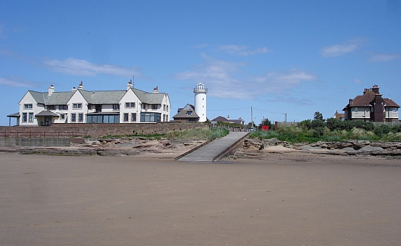
I took this photo yesterday lunchtime. After a really wet start the day ended up being nice and sunny – though there was a stiff breeze about. It’s the view of Red Rocks taken from out on the beach. If the weather is good over the forthcoming Bank Holiday weekend then this corner of the Wirral coast will be a popular spot.
It’s just occurred to me …Stanley Road is most probably the longest dead-end road in Hoylake.
I think Stanley Road’s the longest road in Hoylake full stop isn’t it? Or does Meols Drive pip it before crossing over into WK?!
Hello Rob
hmm close run thing …my money is on Stanley Rd. Don’t think Market St or North Parade get near do they?
Hi John,
I have a childhood memory of measuring Stanley Road and Market Street using the highly accurate method of laying string out on a map! Stanley Road definitely won that one!
Just to the left of the picture, right on the corner where the coast changes direction, there was once something us kids called ‘the target’. It was a solid concrete structure about 6ft high, 8ft long and 5 ft thick at the base. The side facing Hilbre was sloped and was pitted with ‘bullet holes’? The steel fixings can still be seen in the rock.
Couldn’t really be a target could it? I think the nursing home would be a bit close!
I remember that target thing, and I have searched my photos of Red Rocks to see if It was visible, but could not see it. There is a small outcrop of rocks just on the corner at the Hoylake side, and I wonder if it was there?
Fingers crossed someone will remember what it was for.
Also I remember some bits of bent metal on the Municipal Golf Course, usually overgrown with a bramble. These I belive may have been called “Alan Williams” turrets used as light anti aircraft gun emplacements. I wonder if they still exist? The need for scrap metal often meant that this type of turret was quickly removed after the war.
Still puzzling about the “target” thing on the shore at Red Rocks, I found out that lights were fitted between Hilbre and Middle Eye to decoy German Bombers during WWII and there are still signs of the installations if you know where to look. The trick was to make the Dee look like the Mersey and get the Germans to bomb the fields (Any unfortunate sheep were soon appropriated to supplement meagre rations) I am wondering if this “thing” was part of that scheme?
By co-incidence I found there is a talk about WWII decoys on the Wirral taking place at Greasby Library on 13th Sept. (Check, there is a small entry charge). I would love to attend, but am 200 miles away!
Went to the lecture, quite interesting but failed to throw any light on ‘the target’. Hopefully, someone local will enlighten me.